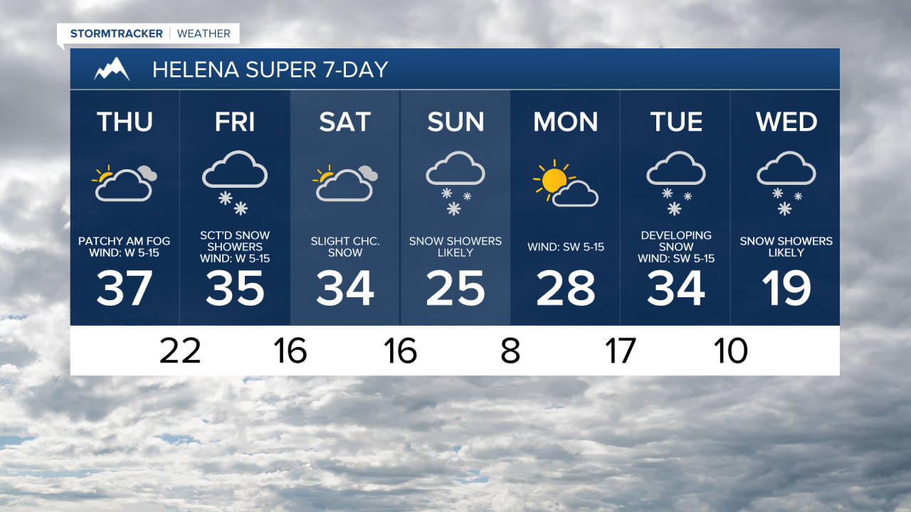
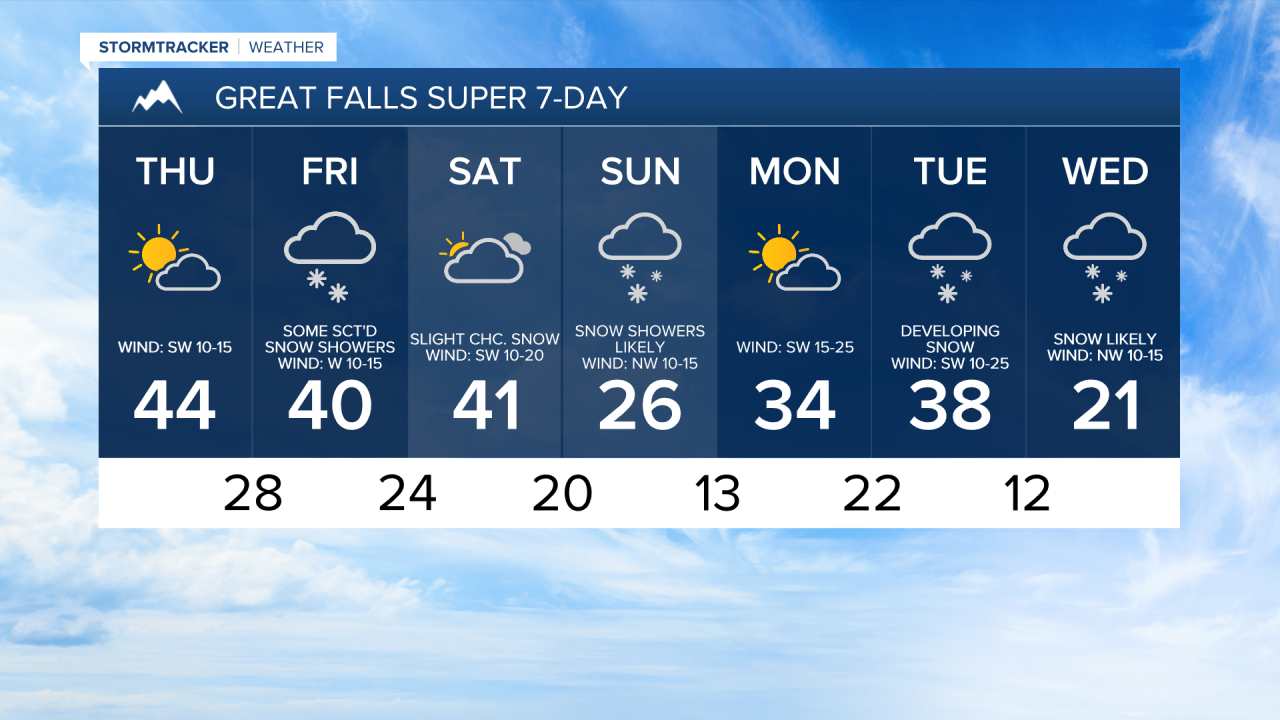
We are going to have partly cloudy skies tonight with some freezing fog around in the valleys and along the central and eastern half of the Hi-Line. It is also going to be chilly tonight as lows are going to be in the teens and low to mid 20s in most locations. The wind is also going to increase tonight along the Rocky Mountain Front and in the Cascade County area.
For tomorrow, we are going to have partly cloudy skies with patchy freezing fog around during the morning in the valleys and along the central and eastern half of the Hi-Line. It is also going to be gusty tomorrow along the Rocky Mountain Front as sustained wind speeds are going to be between 15 and 30 mph, and it is going to be a bit breezy tomorrow in portions of north-central Montana as sustained wind speeds are going to be between 10 and 20 mph. We are also going to have above average temperatures tomorrow as highs are going to be in the mid to upper 30s and low to mid 40s in most locations.
There are then going to be some scattered snow showers around on Friday, especially in the mountains, as a disturbance passes through our area. Little to no snow accumulation is expected in the lower elevations, and light snow accumulations are possible in the mountains. We are also going to have mostly cloudy skies on Friday with decreasing clouds during the afternoon and evening. Widespread breezy conditions are also expected on Friday as sustained wind speeds are going to be between 10 and 25 mph. Also, highs on Friday are going to be in the 30s and low 40s in most locations.
On Saturday, we are going to have increasing clouds with a few isolated snow showers around, especially during the evening, as a cold front begins to approach our area. Snow showers are then likely on Sunday as this cold front passes through our area, and light snow accumulations of a coating to a couple inches are possible in the lower elevations. It is also going to be mostly cloudy on Sunday.
The temperatures are also going to cool down some this weekend as highs are going to be in the 30s and low 40s on Saturday, and the 20s on Sunday. There is also going to be a breeze around in some areas on Saturday as sustained wind speeds are going to be between 10 and 20 mph, and it is going to be a little breezy in some locations on Sunday as sustained wind speeds are going to be between 5 and 20 mph.
We are then going to have partly cloudy skies and mainly dry conditions on Monday as we are going to be in between disturbances. It is also going to be warmer on Monday than it is going to be on Sunday as highs are going to be in the mid to upper 20s and low to mid 30s. Gusty winds are also expected on Monday as sustained wind speeds are going to be between 10 and 30 mph, and wind gusts up to 40 mph are possible.
On Tuesday, we are going to have developing snow throughout the day as a stronger cold front begins to impact our area. There are then going to be areas of snow around on Wednesday as this cold front continues to work its way through our area. The temperatures are also going to cool down a lot over these two days as highs are going to be in the 30s on Tuesday and the mid to upper teens and low to mid 20s on Wednesday. There is also going to be a breeze around on Tuesday as sustained wind speeds are going to be between 10 and 25 mph.