


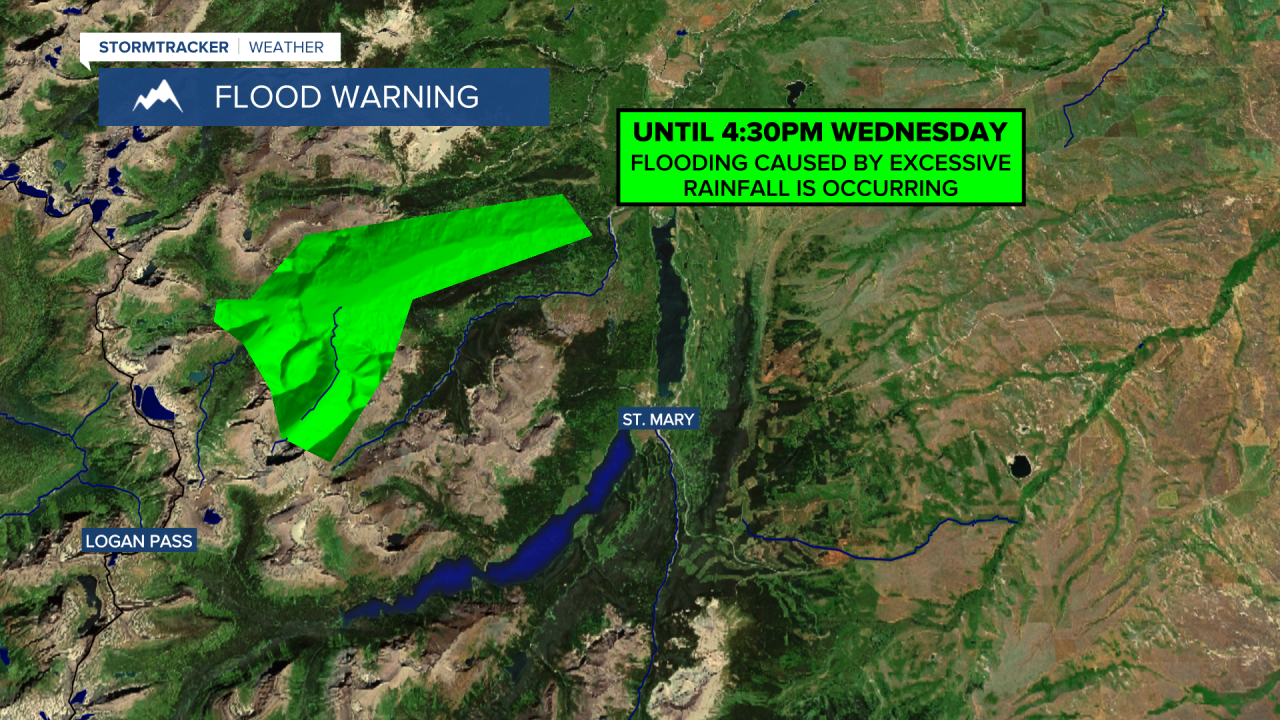
Good Morning and Happy Wednesday! A FLOOD WARNING remains in effect for the Many Glacier Valley in Glacier National Park until 4:30pm Wednesday. The worst is over with and the water levels are going down, but there is still some flooding ongoing in this area. This warning should be allowed to expire later on today.
It was a hazy day yesterday as smoke from Canadian wildfires was brought into the state via northwesterly flow aloft. There will continue to be some haze around today, although it will not be as thick as it was yesterday and the haze will diminish some as the day goes on. Only minor impacts to the air quality are expected as the air quality will be in the “moderate” or “good” category in most locations.
Here is today's forecast:
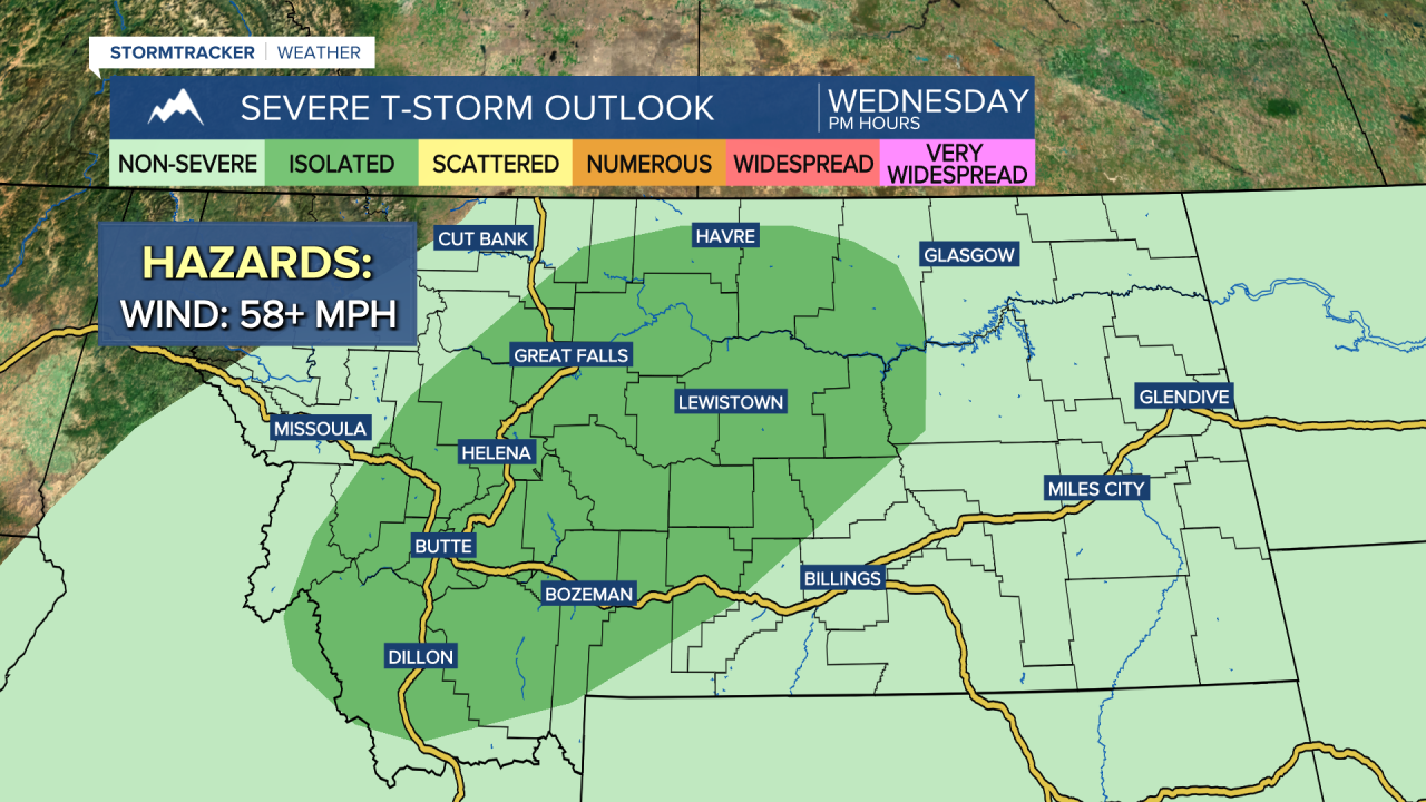
Outside of the haze, you can expect partly to mostly sunny skies today, with the cloud cover increasing as the day goes on. In north-central Montana, there will be some scattered showers and thunderstorms around this afternoon and evening, generally in southern portions of north-central Montana. Around Helena, there will be scattered showers and thunderstorms around this afternoon and evening. A few of the thunderstorms that develop later on today may be severe with damaging winds (58+ mph), so make sure you keep an eye to the sky if you are going to be outdoors at all!
It will be mild again today as highs are going to be in the mid to upper 60s and low to mid 70s around Helena and the 70s and low 80s in north-central Montana. There will also be a breeze around today along the Divide and the Rocky Mountain Front as sustained wind speeds are going to be between 10 and 20 mph. Elsewhere, there will only be a little breeze around today.
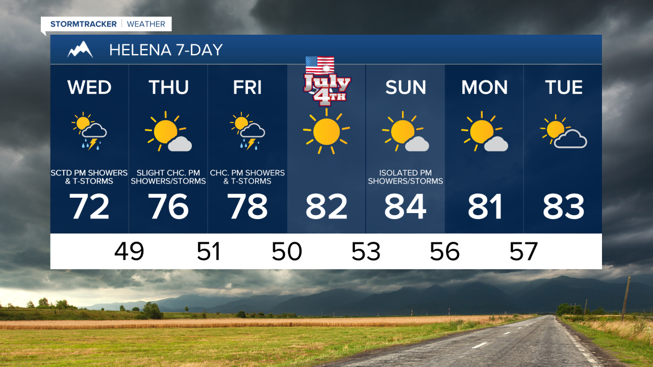
Tomorrow will be a nice day with partly to mostly sunny skies and warm temperatures as highs are going to be in the 70s and low 80s in most locations. Most locations will also remain dry tomorrow, but there will be some isolated showers and thunderstorms around, generally during the afternoon/evening and mainly in locations east of I-15. There will also be little to no wind around in most locations tomorrow, but it will continue to be breezy (10-20 mph) along the Divide and the Rocky Mountain Front.
On Friday, it is going to be partly to mostly sunny and there will be some scattered showers and thunderstorms around during the afternoon/evening, generally in locations east of I-15, as another disturbance passes through the state. It will also be warm on Friday as highs are going to be in the mid to upper 70s and low to mid 80s and there will be a little breeze around as sustained wind speeds are going to be between 5 and 20 mph.
Beautiful weather is in the forecast for the upcoming holiday weekend as an upper-level ridge is going to be in control of our weather. Independence Day will have almost perfect weather with lots of sunshine, dry conditions, and warm temperatures as highs are going to be in the upper 70s and low to mid 80s. There is also going to be a bit of a breeze around on Saturday as sustained wind speeds are going to be between 10 and 20 mph.
Sunday will feature nice weather as well as it is going to be mostly sunny and warm with highs in the 80s. Many locations will also remain dry on Sunday, although there will be some isolated showers and thunderstorms around during the afternoon and evening.
The warm weather sticks around for the beginning of next week as highs on Monday and Tuesday are going to be in the 80s and upper 70s. On Monday, it is going to be mostly sunny and dry. On Tuesday, it is going to be partly to mostly sunny and there will be a few isolated showers and thunderstorms around.

Have a wonderful Wednesday!
Chief Meteorologist Ryan Dennis
