A WINTER STORM WATCH is in effect for some of the mountains in southwestern and south-central Montana from 12am/6am Friday until 6am Sunday.

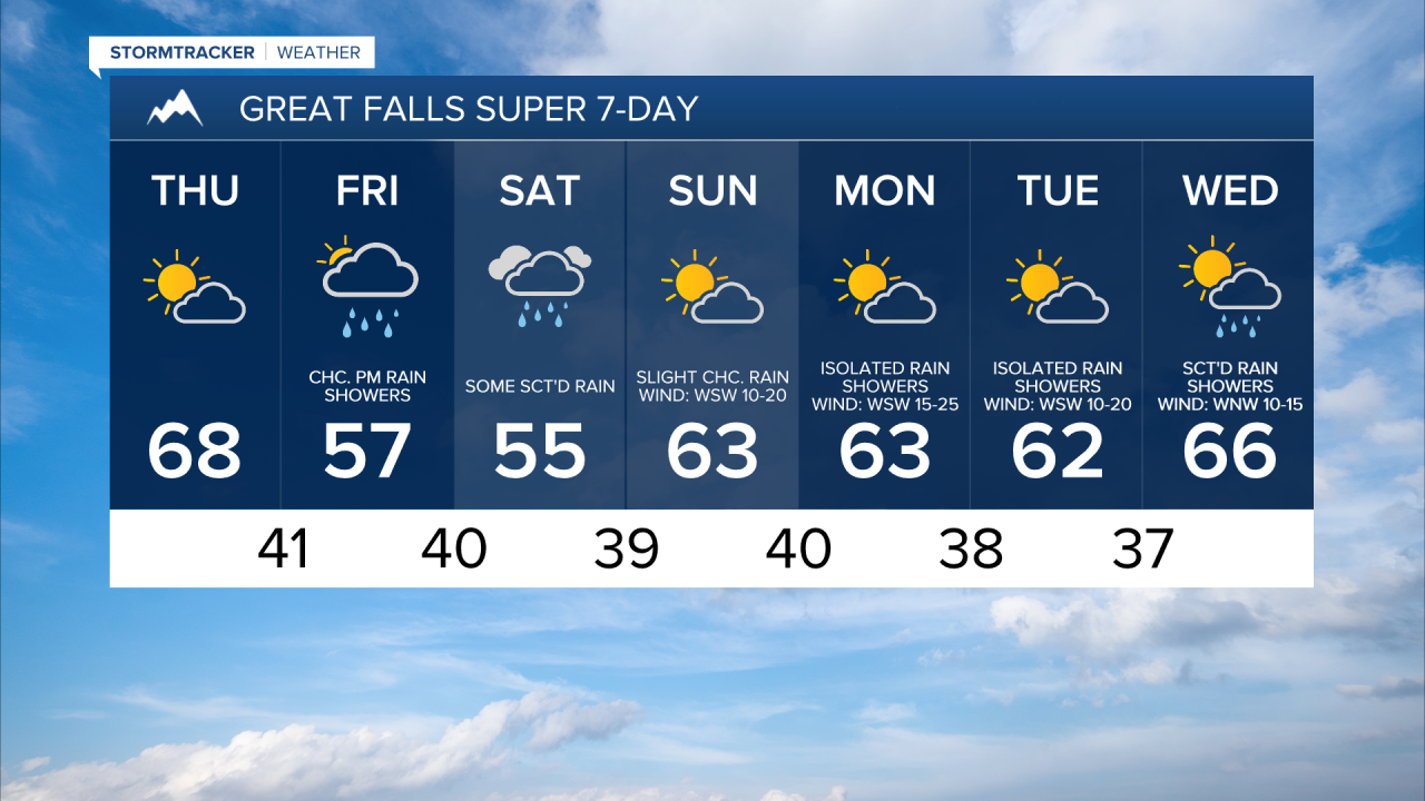
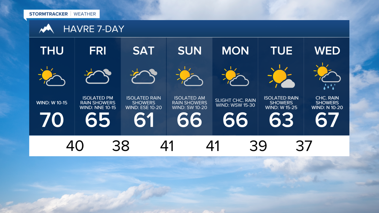
There are going to be a few scattered rain showers around tonight as a disturbance passes through our area. We are also going to have partly to mostly cloudy skies and cool temperatures tonight as lows are going to be in the upper 30s and low to mid 40s in most locations. It is also going to be breezy tonight along the Rocky Mountain Front as sustained wind speeds are going to be between 10 and 20 mph.
For tomorrow, we are going to have partly cloudy skies, mostly dry conditions (just a couple isolated rain showers around), and mild temperatures as highs are going to be in the 60s and low to mid 70s, with the warmest temperatures in northeastern Montana. It is also going to be breezy tomorrow along the Rocky Mountain Front and along western portions of the Hi-Line as sustained wind speeds are going to be between 10 and 25 mph, and it is going to be a bit breezy tomorrow in some other areas as sustained wind speeds are going to be between 10 and 20 mph.
In central Montana, including around Helena, rain and mountain snow/rain showers are likely on Friday, generally during the afternoon/evening, and rain and mountain snow/rain is likely on Saturday as a storm system impacts our area. In north-central Montana, there are going to be a few scattered rain and mountain snow/rain showers around on Friday, generally during the afternoon/evening and generally in central and western portions of north-central Montana, and there is going to be some scattered rain and mountain snow/rain around on Saturday, generally in western portions of north-central Montana, as this storm system impacts our area. Eastern portions of north-central Montana will be mostly dry on these two days. We are also going to have mostly cloudy to overcast skies on these two days.
It is also going to be breezy in some areas on Friday as sustained wind speeds are going to be between 10 and 20 mph. We are also going to have a wide range of temperatures on Friday and Saturday as highs on Friday are going to range from the low 50s to the low 70s, and highs on Saturday are going to range from the upper 40s to the mid 60s, with the warmest temperatures on both days in eastern portions of north-central Montana.
We are then going to have partly cloudy skies on Sunday with a few scattered rain showers around, especially in the mountains, as a storm system leaves our area and as a weak disturbance passes through our area. It is also going to be breezy and warmer on Sunday as sustained wind speeds are going to be between 10 and 25 mph, and highs are going to be in the upper 50s and low to mid 60s.
There are then going to be a few widely scattered rain showers around in north-central Montana on Monday and Tuesday and there are going to be some scattered rain showers around Helena on Monday and Tuesday as a couple more disturbances pass through our area. We are also going to have partly cloudy skies and pleasant temperatures on these two days as highs are going to be in the 60s and mid to upper 50s in most locations. Gusty winds are also expected on Monday as sustained wind speeds are going to be between 10 and 30 mph, and it is going to be breezy on Tuesday as sustained wind speeds are going to be between 10 and 25 mph.
There are then going to be scattered rain showers around on Wednesday, generally during the afternoon and evening, as another disturbance passes through our area. It is also going to be mild on Wednesday as highs are going to be in the 60s and low 70s in most locations.