The short term forecast has some good news! The long term forecast... not so much.
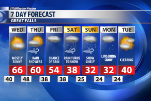
Our Wednesday is looking like a nice, fall day. The strong winds we've seen Tuesday will be dying down, and the thunderstorms we've seen in Northeast Montana will be clearing out too. We'll see a good amount of sunshine, and temperatures will be near normal, in the 60s.
By Thursday and Friday scattered rain showers will begin to move into the state, as well as some snow above 7,000 feet.
At lower elevations rain will turn over to snow by Saturday, and snow will last into Sunday, with flurries lingering as late as Monday.
Accumulating snow is expected for much of North Central Montana.
Heavy snow will be possible as well, especially along and adjacent to the Rocky Mountain Front.
There, a Winter Storm Watch is in effect starting Friday night and lasting into Sunday.
Given the potential for major winter weather impacts, we will be watching this storm very closely.
Click here for details on the Winter Storm Watch .
Stay tuned for updates and more details on timing and snowfall amounts as the snow draws closer.