A LAKE WIND ADVISORY is in effect until 9pm Thursday for Fort Peck Lake. Sustained wind speeds are going to be between 20 and 30 mph, and wind gusts up to 45 mph are going to be possible at times.

It is going to be chilly tonight as lows are going to be in the 30s in most locations. There are also going to be some areas of frost around tonight, so make sure you take the necessary precautions to protect any sensitive vegetation that you may have. We are also going to have mostly to mainly clear skies tonight with a few patchy areas of fog around after midnight. Gusty winds are also expected tonight in northeastern Montana as sustained wind speeds are going to be between 10 and 25 mph, and wind gusts up to 40 mph are going to be possible at times.
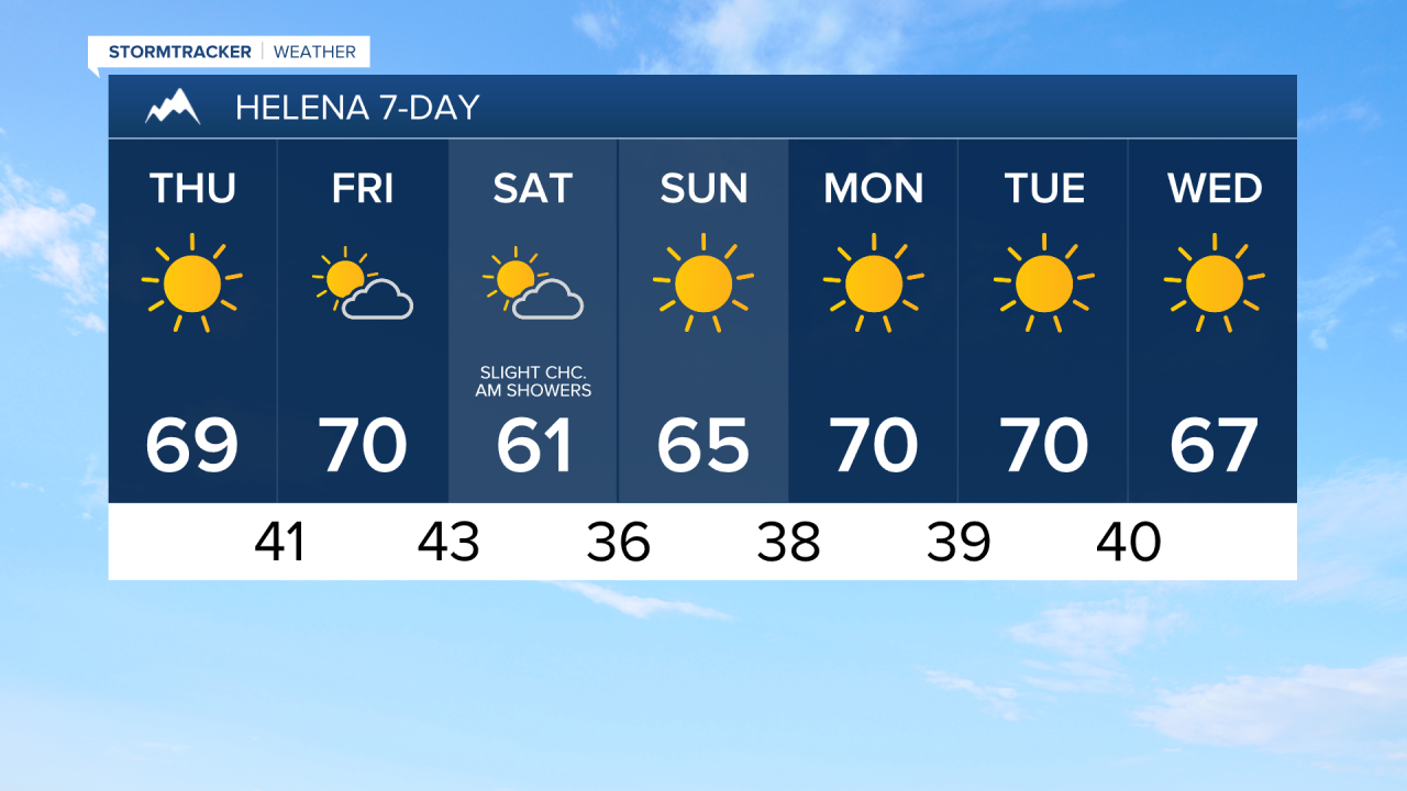
For tomorrow, we are going to have lots of sunshine, dry conditions, and warmer temperatures as highs are going to be in the mid to upper 60s and low 70s. We are also going to continue to have gusty winds around tomorrow in northeastern Montana and eastern portions of north-central Montana as sustained wind speeds are going to be between 10 and 30 mph, and wind gusts over 40 mph are going to be possible at times.
On Friday, we are going to have increasing clouds with a few isolated showers around during the afternoon and evening as a cold front begins to approach our area. There are then going to be a few scattered rain and mountain snow showers around Friday night as this cold front passes through our area. We are then going to have partly cloudy skies on Saturday with a few lingering rain and mountain snow showers around during the morning as this cold front leaves our area. Not a lot of precipitation is expected with this cold front, and more locations will remain dry than see precipitation. This is also basically our only chance of precipitation over the next week.
The temperatures are also going to cool down some between Friday and Saturday as highs on Friday are going to be in the mid to upper 60s and low 70s, and highs on Saturday are going to be in the upper 50s and low 60s. It is also going to be breezy in portions of north-central Montana on Friday as sustained wind speeds are going to be between 10 and 25 mph, and wind gusts up to 40 mph are going to be possible at times.
Mostly to mainly sunny skies, dry conditions, and little to no wind is then expected from Sunday through Wednesday as an upper-level ridge is once again going to be in control of our weather. We are also going to have above average temperatures during these four days as highs are going to be in the 60s on Sunday; the upper 60s and low to mid 70s on Monday and Tuesday; and the mid to upper 60s and low 70s on Wednesday.