We are going to have clear skies and chilly temperatures tonight as lows are going to be in the single digits, teens, and low to mid 20s, with the coldest temperatures along the Hi-Line and in the valleys. Patchy fog may also develop again tonight in the valleys in central and southwestern Montana. It is also going to be breezy tonight along the Rocky Mountain Front as sustained wind speeds are going to be between 10 and 25 mph, and it is going to be a little breezy tonight in some locations east of the Rocky Mountain Front as sustained wind speeds are going to be between 5 and 20 mph.
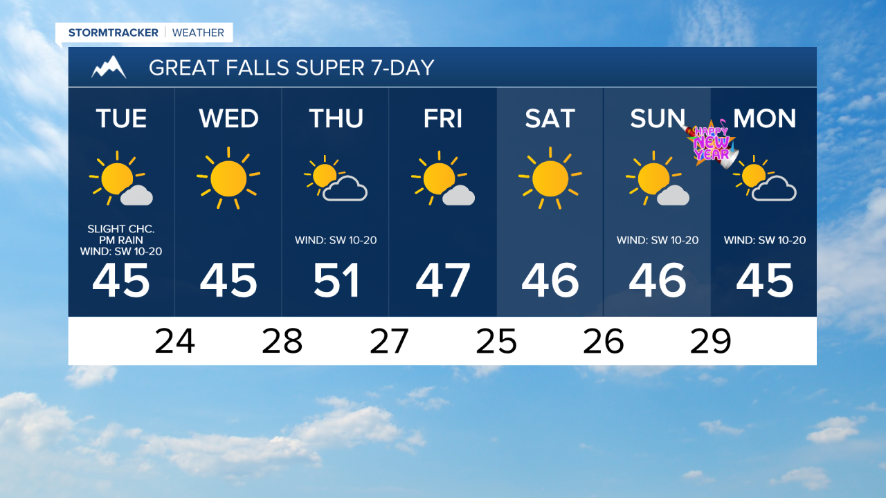
For tomorrow, we are going to have increasing clouds with some isolated rain and snow showers around, generally during the afternoon and evening, as a disturbance passes through our area. We are also going to have gusty winds around tomorrow along the Rocky Mountain Front as sustained wind speeds are going to be between 15 and 30 mph, and it is going to be breezy tomorrow in some locations east of the Rocky Mountain Front as sustained wind speeds are going to be between 10 and 20 mph. It is also going to be cool tomorrow as highs are going to be in the 30s and low to mid 40s in most locations.
On Wednesday, we are going to have mostly sunny skies, mainly dry conditions, just a little breeze, and pleasant temperatures as highs are going to be in the mid to upper 30s and low to mid 40s in most locations. We are then going to have decreasing clouds and mainly dry conditions on Thursday. It is also going to be warmer on Thursday than it is going to be tomorrow and Wednesday as highs are going to be in the 40s and low to mid 50s. There is also going to be a breeze around on Thursday as sustained wind speeds are going to be between 10 and 20 mph.
Mostly sunny skies and mainly dry conditions are then expected on Friday, Saturday, and Sunday as high pressure is going to be in control of our weather. The temperatures on these three days are also going to be above average for this time of year as highs are going to be in the 40s and upper 30s in most locations. It is also going to be breezy in some areas on Sunday as sustained wind speeds are going to be between 10 and 20 mph.
We are then going to have partly cloudy skies on Monday with a slight chance of rain and snow showers as a disturbance begins to impact our area. It is also going to be breezy and cool on Monday as sustained wind speeds are going to be between 10 and 20 mph and highs are going to be in the upper 30s and low to mid 40s in most locations.