A RED FLAG WARNING is in effect until 9pm Thursday for a lot of Montana. Hot temperatures, gusty to strong winds, and low relative humidity are going to allow new fire starts and current wildfires to grow rapidly. Please do your part to not start any new fires!

A HIGH WIND WARNING is in effect for Glacier County, Hill County, northern Lewis and Clark County, Liberty County, Pondera County, western Teton County, and Toole County until 9pm Thursday. Sustained wind speeds are going to be between 30 and 40 mph, and wind gusts up to 65 mph are going to be possible at times.

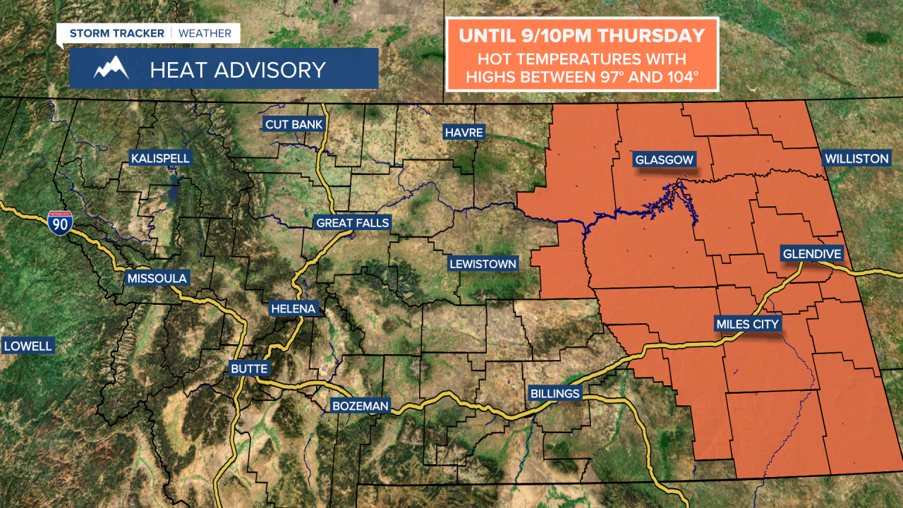
A HEAT ADVISORY is in effect for eastern Montana until 9pm/10pm Thursday. It is going to be hot this evening as temperatures are going to be in the 90s and low 100s.
The wind is going to gradually diminish as we go through this evening and the first part of tonight, with just a little breeze around after midnight. It is also going to be cooler tonight than it was last night as lows are going to be in the 50s in most locations. There are also going to be a few scattered showers and thunderstorms around in eastern Montana and eastern portions of central Montana this evening and tonight, mainly before midnight. A couple of these thunderstorms may also be severe with 60+ mph winds. We are also going to have areas of smoke and thicker haze around tonight due to the smoke plumes from the Elmo, Hog Trough, and Moose fires. Outside of the smoke and haze, you can expect partly cloudy to mostly clear skies tonight.
For tomorrow, we are going to have partly cloudy to mostly sunny skies with a slight chance of showers and thunderstorms during the evening around the Helena area. There are also going to continue to be areas of haze and smoke around tomorrow, although a cold front will bring some cleaner air into our area from north to south tomorrow afternoon/evening and tomorrow night.
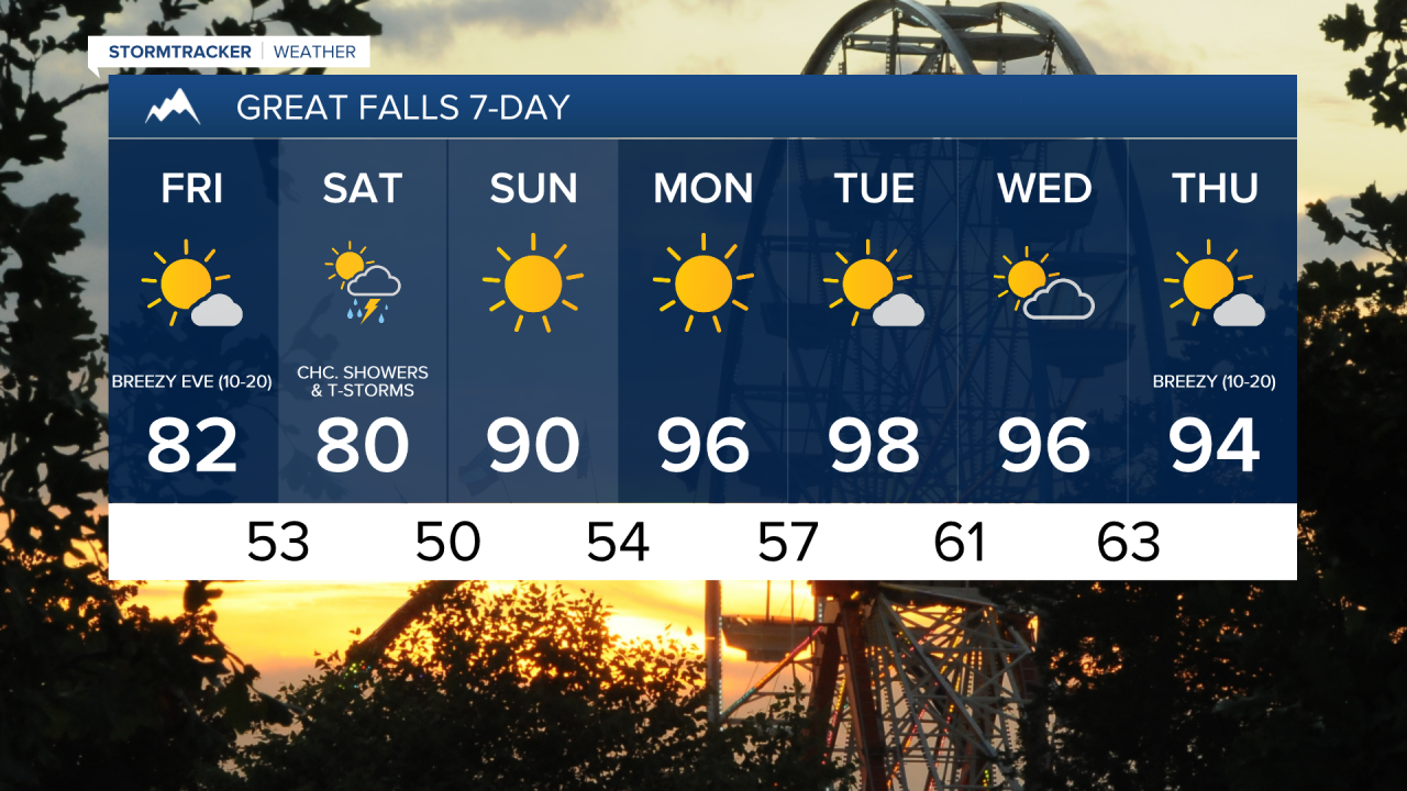
The wind is also going to be weaker tomorrow than it was today, but it is still going to be breezy, especially during the afternoon and evening, as sustained wind speeds are going to be between 10 and 25 mph, and wind gusts up to 40 mph are going to be possible at times. Also, the wind tomorrow is going to be coming out of the north. It is also going to be cooler tomorrow than it has been over the past several days as highs are going to be in the mid to upper 70s and low to mid 80s.
There are then going to be showers and thunderstorms around on Saturday, especially in southern, central, and eastern portions of Montana, as a storm system works its way through our area. It is also going to be mild/cool on Saturday as highs are going to be in the 60s and 70s. There is also just going to be a little breeze around on Saturday. Partly to mostly cloudy skies are also expected on Saturday.
Lots of sunshine and dry conditions are then expected on Sunday, Monday, and Tuesday as high pressure is going to be in control of our weather. The temperatures are also going to warm up some over these three days as highs on Sunday are going to be in the mid to upper 80s and low 90s; highs on Monday are going to be in the 90s; and highs on Tuesday are going to be in the mid to upper 90s and low 100s.
For Wednesday and Thursday, we are going to have a mix of sun and clouds with some isolated showers and thunderstorms around, generally during the evening hours and generally around the Helena area. It is also going to be hot and a little breezy on these two days as highs are going to be in the 90s and sustained wind speeds are going to be between 5 and 20 mph.