


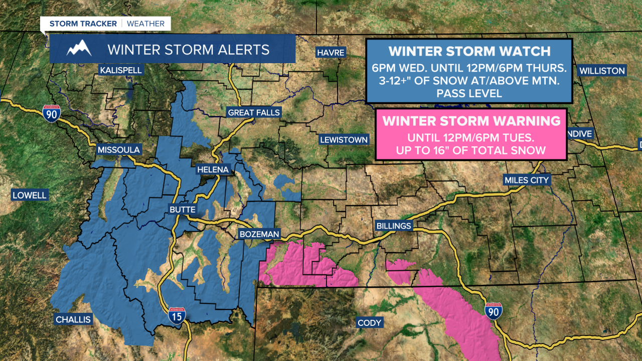
A WINTER STORM WATCH is in effect for several of the mountain ranges in central and southwestern Montana from 6pm Wednesday until 12pm/6pm Thursday.
A WINTER STORM WARNING is in effect for the Absaroka, Beartooth, Bighorn, and Pryor mountains until 12pm/6pm Tuesday.
A FLOOD WATCH is in effect for the Highwood and Little Belt mountains from 6pm Wednesday until 12pm Friday.

There are going to be some scattered rain showers and a few thunderstorms around this evening and tonight, especially before midnight, as a disturbance continues to impact our area. We are also going to have partly cloudy skies tonight with some patchy areas of fog around. It is also going to be chilly tonight as lows are going to be in the 30s and low 40s.
For tomorrow, we are going to have partly cloudy skies (via increasing clouds) with scattered rain showers and a few thunderstorms around, mainly during the afternoon/evening and especially in locations east of I-15, as another disturbance passes through our area. It is also going to be breezy tomorrow along the Rocky Mountain Front as sustained wind speeds are going to be between 10 and 25 mph. We are also going to have pleasant temperatures tomorrow as highs are going to be in the mid to upper 50s and low to mid 60s.
A larger storm system is then going to impact Montana on Wednesday and Thursday. On Wednesday, rain/mountain snow showers and some thunderstorms are likely, generally during the afternoon and evening, as this storm system begins to impact our area. There is then going to be widespread rain/mountain snow and a few thunderstorms around Wednesday night and Thursday morning. Precipitation will then gradually taper off Thursday afternoon and evening as this storm system begins to leave our area.
The snow levels will also drop as we go through Wednesday night and may get as low as 4000 to 5000 feet by Thursday morning, which means that some lower elevation locations will see some snow fly. The snow levels will then gradually rise back up to about 6000 feet as we go through Thursday. We are also going to have mostly cloudy to overcast skies from Wednesday morning through midday Thursday, with some decrease in the cloud cover Thursday afternoon/evening.
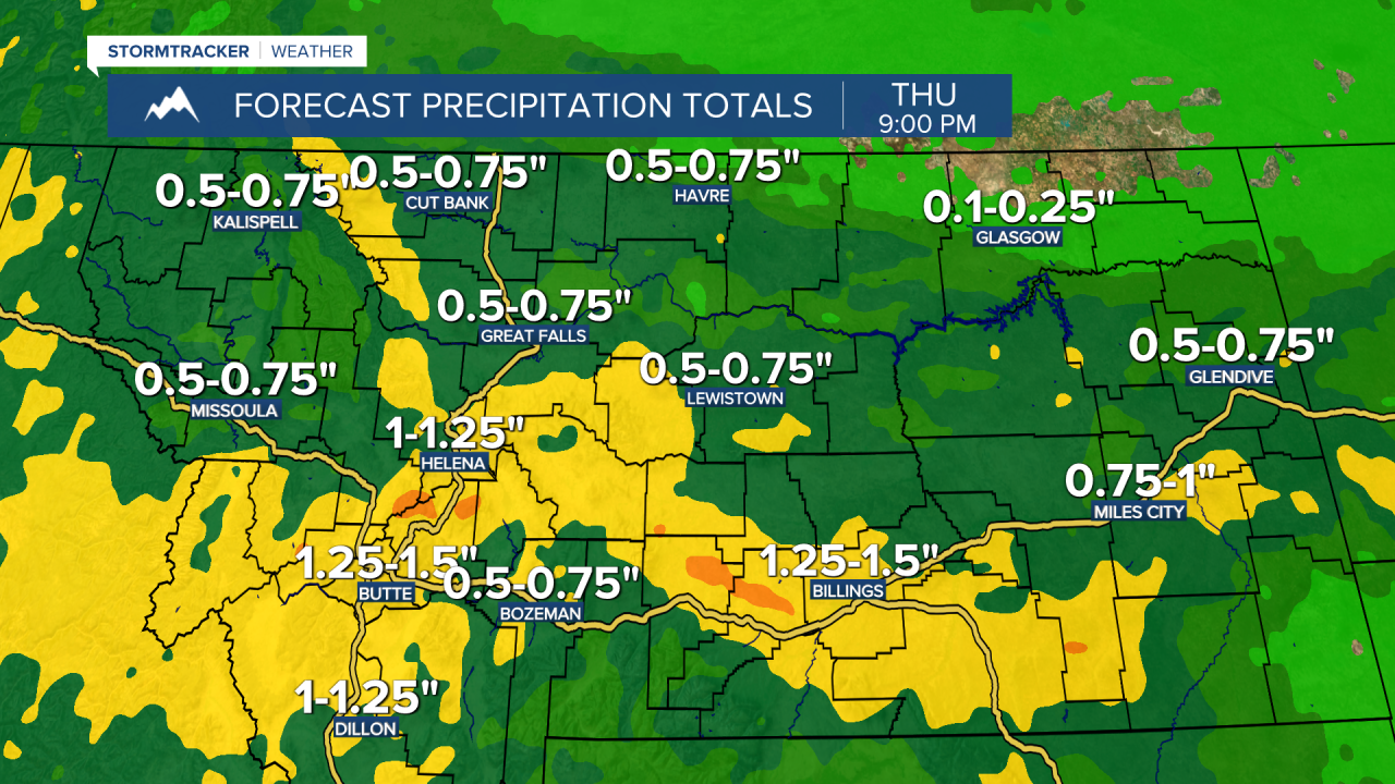
Between Monday evening and Thursday evening, a lot of locations in Montana will receive between .5” and 1.5” of precipitation, with the highest precipitation amounts expected in southwestern, south-central, and central Montana. In north-central Montana, precipitation amounts will get lower the further east you go, with less than a quarter inch of precipitation expected in northeastern Montana. Also, the bulk of this precipitation will fall on Wednesday and Thursday.
Between Monday evening and Thursday evening, 3-12+” of snow accumulation is expected at and above mountain pass level in the mountains in central and southwestern Montana. This snow will create difficult travel conditions over the passes, especially Wednesday night into Thursday morning, so please try and avoid traveling during that time if possible. In the lower elevations, most locations will receive no snow accumulation, but some lower elevation locations, especially those that are near the mountains in central and southwestern Montana, may receive a couple inches of snow accumulation through Thursday evening.

The temperatures are also going to cool down some between Wednesday and Thursday as highs are going to be in the 50s and low to mid 60s on Wednesday and the mid to upper 40s and low to mid 50s on Thursday. It is also going to be breezy on Thursday as sustained wind speeds are going to be between 10 and 25 mph.
We are then going to have pretty nice weather on Friday as we are going to have partly to mostly sunny skies, mostly dry conditions (just a few isolated PM showers and thunderstorms around), and warmer temperatures as highs are going to be in the 60s in most locations. There is also going to be a good breeze around on Friday, especially along the Rocky Mountain Front, as sustained wind speeds are going to be between 10 and 25 mph.
The holiday weekend is going to start off on the wetter, cooler, cloudier, and breezier side of things. Showers and some thunderstorms are likely on Saturday and Sunday, generally from Saturday afternoon through Sunday afternoon, as a storm system passes through our area. We are also going to have mostly cloudy skies on Saturday and partly cloudy skies on Sunday. The temperatures are also going to cool down some between these two days as highs are going to range from the mid 50s to the mid 70s on Saturday (warmest temperatures in northeastern Montana) and highs are going to be in the 50s and low 60s on Sunday. It is also going to be breezy on these two days as sustained wind speeds are going to be between 10 and 25 mph.
Nicer weather is then expected on Memorial Day (Monday) as we are going to have mostly sunny skies, mostly dry conditions (just a few isolated showers/storms around), less wind (sustained wind speeds between 5 and 20 mph), and warmer temperatures as highs are going to be in the 60s and low 70s.


