


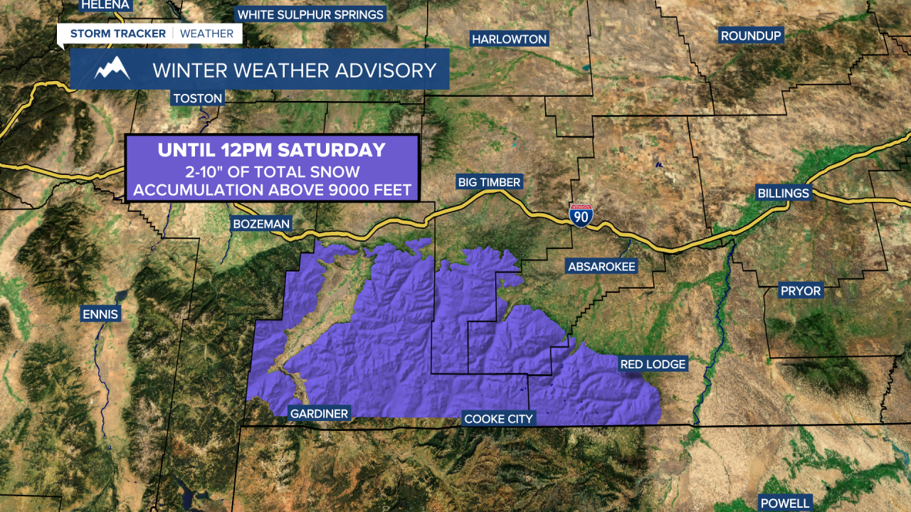
A WINTER WEATHER ADVISORY is in effect for the Absaroka and Beartooth mountains until 12pm Saturday. 2 to 10 inches of total snow accumulation is possible above 9000 feet.
There are going to be areas of rain around this evening and tonight, and some of the rain that falls may be moderate to heavy at times. Up to a half inch of additional rainfall is possible tonight, especially in central Montana and southern portions of north-central Montana. We are also going to have overcast to mostly cloudy skies tonight with a few areas of fog around. It is also going to be cool tonight as lows are going to be in the 40s and low to mid 50s in most locations.
For tomorrow, we are going to have decreasing clouds with some scattered showers around, mainly in locations east of I-15 and especially during the morning, as a storm system to our south works its way into the Dakotas. We are then going to have partly cloudy skies and mainly dry conditions on Sunday. The temperatures are also going to warm up some this weekend as highs are going to be in the 60s and low 70s tomorrow and the 70s and upper 60s on Sunday. There is also only going to be a little breeze around this weekend as sustained wind speeds are going to be between 5 and 15 mph in most locations.
Partly cloudy to mostly sunny skies and mostly dry conditions are then expected on Monday and Tuesday as an upper-level ridge is going to be in control of our weather. It is also going to be mild/warm on these two days as highs are going to be in the 70s and low 80s on Monday and highs are going to range from the mid 60s to the mid 80s on Tuesday. Breezy conditions are also expected on Tuesday as sustained wind speeds are going to be between 10 and 25 mph.
We are then going to have a chance to see some showers and isolated thunderstorms on Wednesday, mainly during the afternoon/evening, as a disturbance passes through our area. We are also going to have partly cloudy skies and cooler temperatures on Wednesday as highs are going to be in the 60s and low to mid 70s in most locations. It is also going to be a bit breezy on Wednesday as sustained wind speeds are going to be between 10 and 20 mph.
On Thursday and Friday, we are going to have partly cloudy skies with a few isolated showers around. The temperatures are also going to continue to cool down over these two days as highs are going to be in the 60s on Thursday, and the mid to upper 50s and low to mid 60s on Friday. There is also going to be a breeze around on Thursday as sustained wind speeds are going to be between 10 and 20 mph.


