


Good Morning! Today is Wednesday, August 12, 2026. Here is today's forecast:
Widespread haze is expected again today and there will be areas of near-surface smoke around as well, so at times, the air quality may be unhealthy for sensitive groups. An AIR QUALITY ALERT remains in effect for all of western and southwestern Montana, including the Helena area, through at least 9am Wednesday.

A cold front will begin pushing south through the region this afternoon, bringing much cleaner air in its wake. While there will still be some haze around tomorrow, especially in western and southern Montana, the visibility and air quality will be significantly better. This cleaner air should remain in place through at least Friday.
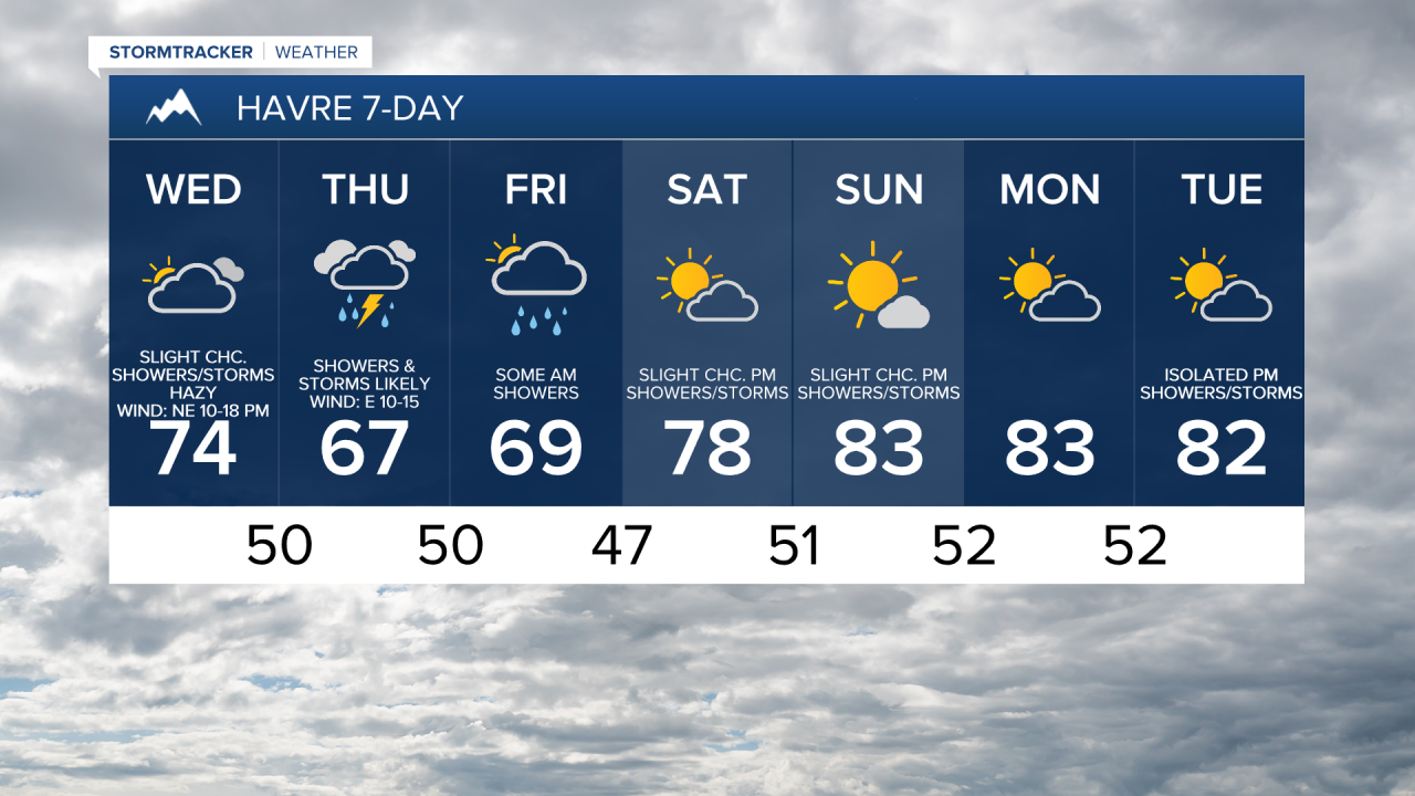
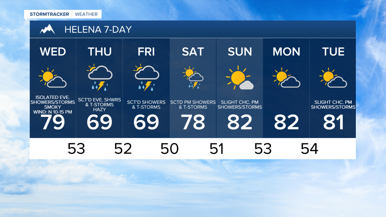
Many locations will remain dry today, but there will be a few scattered showers and thunderstorms around, generally during the evening and generally in central Montana and along/near the Canadian border. It is also going to be partly to mostly cloudy and cooler today as highs are going to be in the 70s, although locations in the Golden Triangle will only top out in the 60s and low 70s. There is also going to be a bit of a breeze around later on today in some areas as sustained wind speeds are going to be between 10 and 20 mph.
There will be scattered showers and thunderstorms around tonight as a disturbance works its way through the state. Tomorrow, there will be scattered showers and thunderstorms around in north-central Montana, generally during the morning, and there will be scattered showers and thunderstorms around the Helena area, generally during the evening. More scattered showers and thunderstorms are then expected on Friday, mainly in central Montana and in locations east of I-15 in north-central Montana and especially during the morning. It is also going to be mostly cloudy to overcast tonight through Friday.
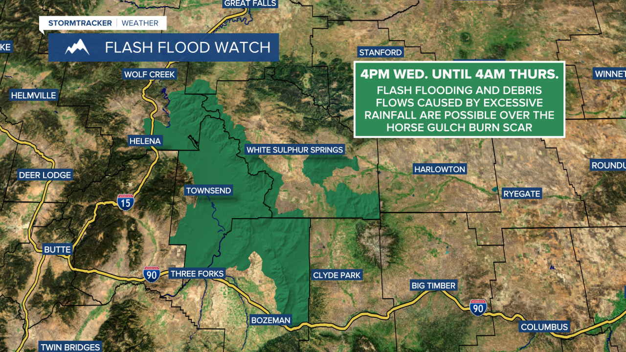
Some of the stronger showers and thunderstorms may produce heavy rainfall, which could lead to localized flash flooding, particularly in urban areas and over recent burn scars. A FLASH FLOOD WATCH is in effect for the Horse Gulch Burn Scar from 4pm Wednesday through 4am Thursday, as flash flooding and debris flows are possible.
Rainfall totals from today through Friday evening will vary considerably. Some areas may receive less than 0.1” of rain, while others could pick up more than 1”. The greatest precipitation amounts are expected across central and eastern Montana, with the lightest amounts in western Montana. Across central and north-central Montana, a lot of locations will likely receive between 0.15” and 0.75” of rainfall.

Well-below-average temperatures are expected tomorrow and Friday, with highs mainly in the 60s and upper 50s. Breezy conditions will continue in some areas tonight and tomorrow, with sustained winds of 10 to 20 mph. The strongest winds tomorrow will occur across eastern portions of north-central Montana.
Temperatures will gradually warm this weekend as another ridge of high pressure builds into the region. Highs on Saturday will climb into the 70s and low 80s, while Sunday’s temperatures will be in the upper 70s and low to mid 80s.
On Saturday, there will be scattered afternoon and evening showers and thunderstorms around the Helena area, and there will be some isolated showers and thunderstorms around later in the day in north-central Montana, generally in the mountains. Skies will be partly cloudy. On Sunday, it is going to be partly to mostly sunny and there will be a few isolated showers and thunderstorms around during the afternoon and evening, generally in the higher terrain.
Some more isolated showers and thunderstorms are possible Monday and Tuesday, but most locations will stay dry under partly cloudy skies. Temperatures will remain warm, with highs generally in the mid to upper 70s and low to mid 80s.


Have a wonderful Wednesday!
Chief Meteorologist Ryan Dennis
