

Today’s weather was more typical of what we get in the fall and spring, not the middle of July! It was a cool day today, with a few locations setting new record cold high temperatures for July 15th.

It was also a rainy day today as most locations in north-central Montana received between .25” and 1.25” of rain. For a full recap of the precipitation totals since Monday evening, head here: https://www.krtv.com/weather/todays-forecast/precipitation-recap-july-14-to-july-15-2025
Scattered showers will continue this evening and tonight, but they will gradually taper off from west to east as the night goes on. Less than .25” of additional rain is expected in most locations, although a few isolated spots may receive up to .5” of additional rain.
It was also a smoky day today as northerly flow aloft and at the surface brought Canadian wildfire smoke into the state. At times, the air quality today was unhealthy for sensitive groups or unhealthy for everyone. There will continue to be wildfire smoke around through tomorrow morning, with the thickest smoke along the Rocky Mountain Front and out to I-15 as well as in the Golden Triangle area between Cut Bank, Havre, and Great Falls. This is where the air quality may be unhealthy for sensitive groups at times. As we go through tomorrow, the smoke will move out, leading to better air quality and improved visibility for everyone.
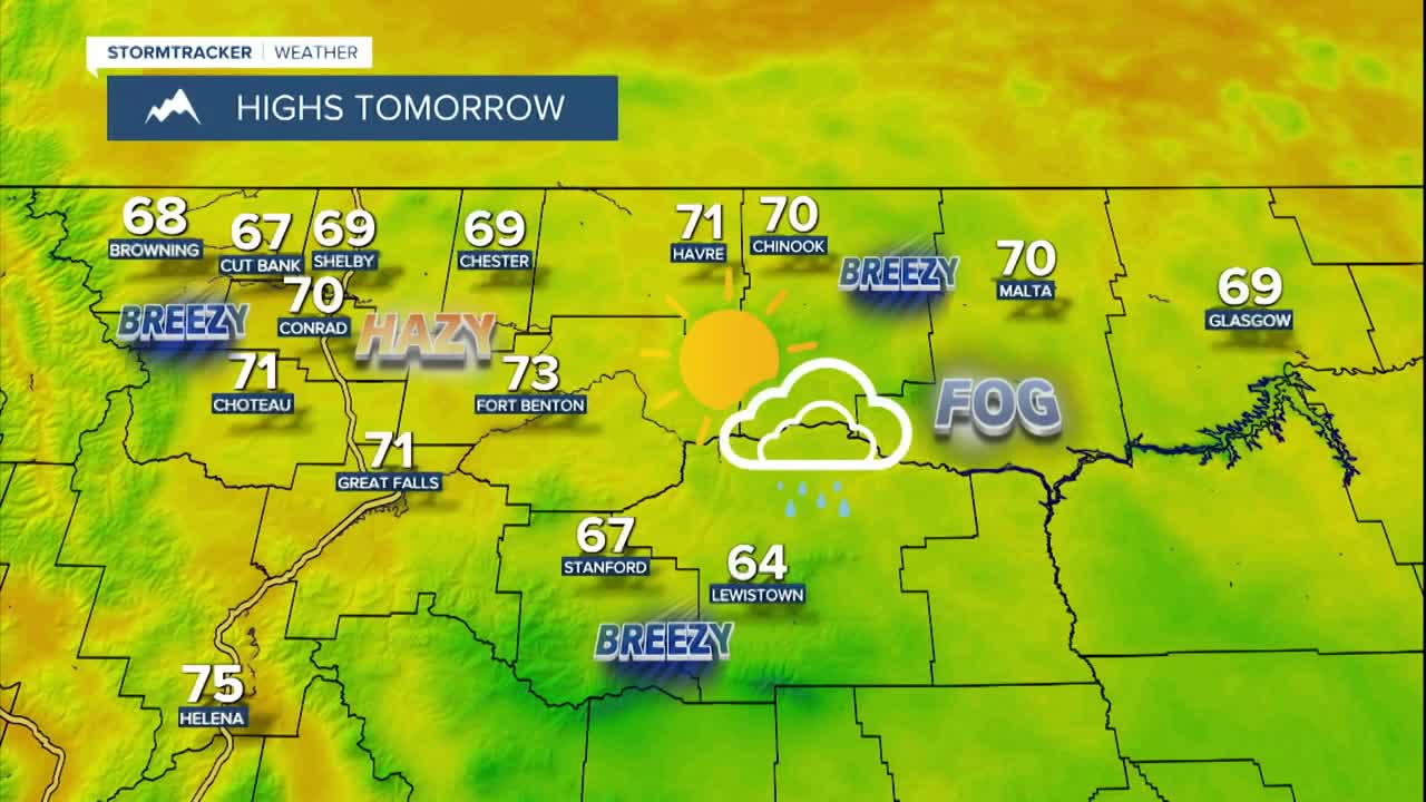
We will start tomorrow off with overcast skies and areas of fog, and some of this fog may be dense. As we go through tomorrow, the fog will burn off and the skies will gradually clear out as we head into the afternoon and evening. A couple lingering showers are possible east of I-15 tomorrow, but most locations will be dry.
We have had gusty winds around again today, but this wind will diminish as we go through this evening and the first half of tonight. It will be a little breezy tomorrow, but the wind will be weaker than it was today, as gusts will generally be below 30 mph. Lows tonight will be in the 40s and low 50s in most locations. It will then be warmer tomorrow than it was today as highs are going to be in the mid to upper 60s and low to mid 70s.
Thursday will feature more sunshine (partly to mostly sunny skies) and pleasant temperatures as highs are going to be in the 70s and low 80s in north-central Montana and the 80s around Helena. There are also going to be a few showers and thunderstorms around Thursday afternoon and evening, generally along the Hi-Line, as a disturbance clips our area. There may also be a few areas of fog around Thursday morning.
We are then going to have mostly sunny skies and mostly dry conditions on Friday as high pressure is going to be in control of our weather. It is also going to be warm and a little breezy on Friday as highs are going to be in the mid to upper 70s and low to mid 80s, and sustained wind speeds are going to be between 5 and 20 mph.
This weekend, we are going to have partly cloudy skies with some isolated showers and thunderstorms around east of I-15. It is also going to be warm this weekend as highs are going to be in the 80s and upper 70s in most locations. There is also going to be a little breeze around this weekend as sustained wind speeds are going to be between 5 and 20 mph.
Another round of scattered showers and thunderstorms is expected next Tuesday as a disturbance passes through our area. Cooler temperatures are also expected as highs are going to be in the mid to upper 60s and low to mid 70s.


