


Hurricane-force winds along the Rocky Mountain Front today, with Browning recording a peak wind gust of 87 mph and Bynum Reservoir recording a peak wind gust of 93 mph! These strong winds blew one trailer of a double trailer over near Browning earlier today. East of the Rocky Mountain Front, the wind wasn’t nearly as strong, but it was still a windy day with peak wind gusts over 40 mph in several locations.

This was a chinook wind, so it was warm today as highs were in the 60s in a lot of locations. Great Falls had a high of 67°, which ties the record high for November 10th, which was previously set in 1913, 1934, and 1971. Several other locations were within a few degrees of tying their record high for November 10th.

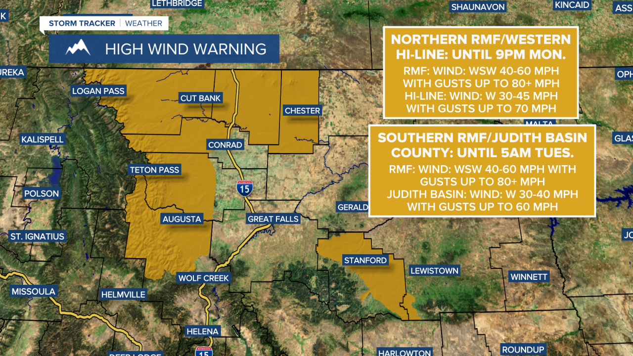
A HIGH WIND WARNING remains in effect for the northern part of the Rocky Mountain Front and the western half of the Hi-Line until 9pm this evening and for the southern part of the Rocky Mountain Front and part of Judith Basin County until 5am tomorrow. It will remain very windy along the Rocky Mountain Front tonight as wind gusts over 60 mph are likely. East of the Rocky Mountain Front, it will be gusty in some areas tonight as wind gusts up to 40 mph are possible. It is also going to be mild tonight as lows are going to be in the mid to upper 30s and low to mid 40s. We are also going to have partly to mostly cloudy skies around Helena and decreasing clouds in north-central Montana tonight. A few isolated rain and mountain snow showers are possible tonight, but most locations will remain dry.
The wind will be weaker tomorrow than it was today, but it is still going to be a gusty day as sustained wind speeds are going to be between 10 and 30 mph, and wind gusts over 40 mph are possible. Outside of the wind, we are going to have lovely weather tomorrow with partly to mostly sunny skies around Helena, mostly sunny skies in north-central Montana, and slightly cooler, but still mild temperatures as highs are going to be in the mid to upper 50s and low 60s in most spots.
Here is the detailed forecast:
We are then going to have mostly cloudy skies with a couple isolated rain/snow showers around on Wednesday and partly cloudy skies and dry conditions on Thursday as an upper-level ridge remains in control of our weather. We will get a break from the wind on Wednesday, but breezy conditions return for some areas on Thursday as sustained wind speeds are going to be between 10 and 25 mph. It is also going to be mild on Wednesday as highs are going to be in the 50s, and it is going to be warm on Thursday as highs are going to be in the 60s in most spots.
A few rain and snow showers are then possible Thursday night into Friday around Helena and in the mountains as a disturbance passes through the state. We are also going to have partly to mostly cloudy skies and cooler temperatures on Friday as highs are going to be in the 50s and upper 40s. Another round of gusty to strong winds is also expected on Friday as sustained wind speeds are going to be between 10 and 30 mph, and wind gusts over 50 mph are possible.
Another disturbance will bring a few rain and snow showers to the state Friday night into Saturday morning, but most of this weekend will be dry with a mixture of sun and clouds. Breezy conditions will continue this weekend as sustained wind speeds are going to be between 10 and 25 mph, and it will be cool this weekend as highs are going to be in the mid to upper 40s and low to mid 50s.


