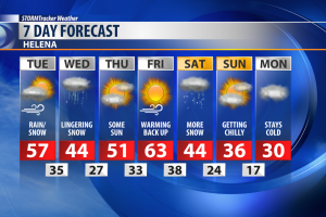
An incoming cold front will ramp up the wind and offer a rain and snow mixture on Tuesday.
A High Wind Warning has been issued for most of Central Montana in anticipation of this incoming weather system.
Sustained winds are expected to be around 35-45 mph with occasional gusts in upwards of 60 mph.
Along with the High Wind Warning, the National Weather Service has also issued a Winter Weather Advisory for portions of Cascade, Judith Basin, and Meagher Counties.
Snow accumulation of 1-3 inches is likely from Belt to Geyser, with greater amounts in the Little Belt Mountains.
Kings Hill Pass also has the possibility of picking up 4-8 inches of snow.
Wind will be the primary impact for most of our area but some light accumulation is likely from this passing weather system.
The wind will let up overnight with lows falling to right around freezing.
A few lingering flurries are likely through the first part of Wednesday.
Temperatures will struggle to reach the mid 40s for Central Montana.
We'll see a nice boost in temperatures as a high pressure ridge builds over the Western United States.
By Friday highs are expected to be well into the 60s, however the trade off will be strong wind.
Our next weather maker is on track to move in over the weekend.