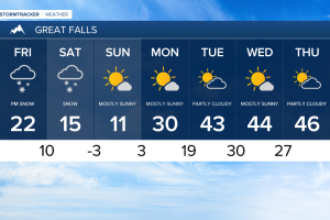
Friday will start out chilly with another round of morning fog. The air will be cold enough that a few stray flurries can't be ruled out early in the day. Daytime highs are expected to remain in the low to mid 20s for most. Clouds will begin to build around the noon hour as our next snow maker track into the region.
This next system will have more moisture to work with and is expected to resemble last weekends storm. The National Weather Service has a Winter Storm Warning scheduled for this evening in anticipation of this system. We'll likely begin to see a few flurries around 4:00pm along the Rocky Mountain Front. The snow is expected to pick up around 6pm and increase significantly around 9:00pm.
Widespread and heavy snow is on track to stick with us throughout the day Saturday. Temperatures will struggle to break out of the mid teens as the arctic air continues to settle in.
The snow should begin to taper off Saturday evening and eventually come to an end by Sunday morning. Nearly all of North Central Montana is expected to pick up 12 to 18 inches of snow through Sunday morning
The heavy snow will begin to taper off around Lewistown, with this area picking up 8 to 12 inches. Havre will be right on the edge of the heavy snow and is expected to receive 3 to 5 inches once it's all said and done.
This incoming air mass will keep daytime high temperatures in the teens through Sunday. The cold arctic air will begin to lift out of the region on Monday allowing for daytime highs to return to the high 20s and low 30s. Still warmer air is anticipated to move in by Wednesday likely melting most of the new snow accumulation.