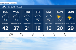
Scattered showers and chilly temperatures will make for an icy commute Tuesday morning.
Black ice has been observed throughout the area and extreme caution should be used on bridges and overpasses.
The spotty rain showers and flurries are expected to taper off as the day plays out.
Highs Tuesday afternoon are expected in the low to mid 40s for most.
Our next aggressive weather maker moves in Wednesday afternoon.
Colder air and north Pacific moisture are expected to invade allowing for a steep drop in temperatures overnight and more snow accumulation.
In anticipation of the winter weather conditions The National Weather Service has a Winter Storm Warning scheduled for Wednesday.
An additional 3 to 5 inches are very likely out of this next system for Great Falls.
Areas along the Rocky Mountain front are expected to pick up closer to 5 to 8 inches.
Helena will likely see 1 to 3 inches.
Temperatures are on track to remain in the teens and single digits following the passage of this system.
The very cold overnight lows are expected to last through the weekend.
Forecast models are hinting at another round of snow Friday night into Saturday.
The brunt of the snow form this system is expected to stay to our south.
If this weekend system moves a bit further north much greater snow accumulations are possible.