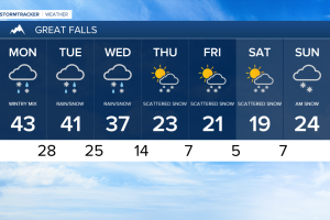
Snow continues Monday morning, eventually turning to a wintry mix as the day plays out.
Some patch fog is likely due to the high moisture content in the air and warming temperatures.
Daytime highs are expected in the mid to high 40s for most this afternoon.
Scattered showers are expected throughout Central Montana with periods of light snow this evening.
Some additional accumulation is likely with most remaining in the mountains and east of Great Falls and Helena.
Temperatures will fall below freezing overnight allowing for very icy conditions once again.
Spotty flurries are expected to taper off on Tuesday with highs in the 40s.
Our next aggressive weather maker moves in Wednesday afternoon.
Colder air and north Pacific moisture are expected to move in allowing for a steep drop in temperatures overnight and more snow accumulation.
An additional 3 to 5 inches are very likely out of this next system.
Temperatures are on track to remain in the teens and single digits following the passage of this system.
Forecast models are hinting at another round of snow this weekend.