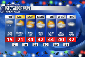
The slight break from the snow will give you just enough time to clear the driveway before round two moves in.
As the driving force behind our recent weather tracks east, it will continue to wrap moisture over Montana. We should see the snow ramp back up around the noon hour and last through Saturday morning. The heaviest snow will stay East of I-15 on Friday.
On average most of Central Montana will pick up an additional 5 to 8 inches of snow. Eastern Montana will have the potential to see greater accumulations.
Weather conditions will begin to improve on Sunday. Next week will offer up more sun and temperatures back in the high 30s and low 40s.
The potential for wind will need to be monitored closely this next week. As of right now Tuesday is expected to be the windiest.
WINTER WEATHER RESOURCES:
- STORMTracker Weather page
- Live interactive radar
- STORMTracker on Facebook
- Montana webcams
- MDT Road Conditions