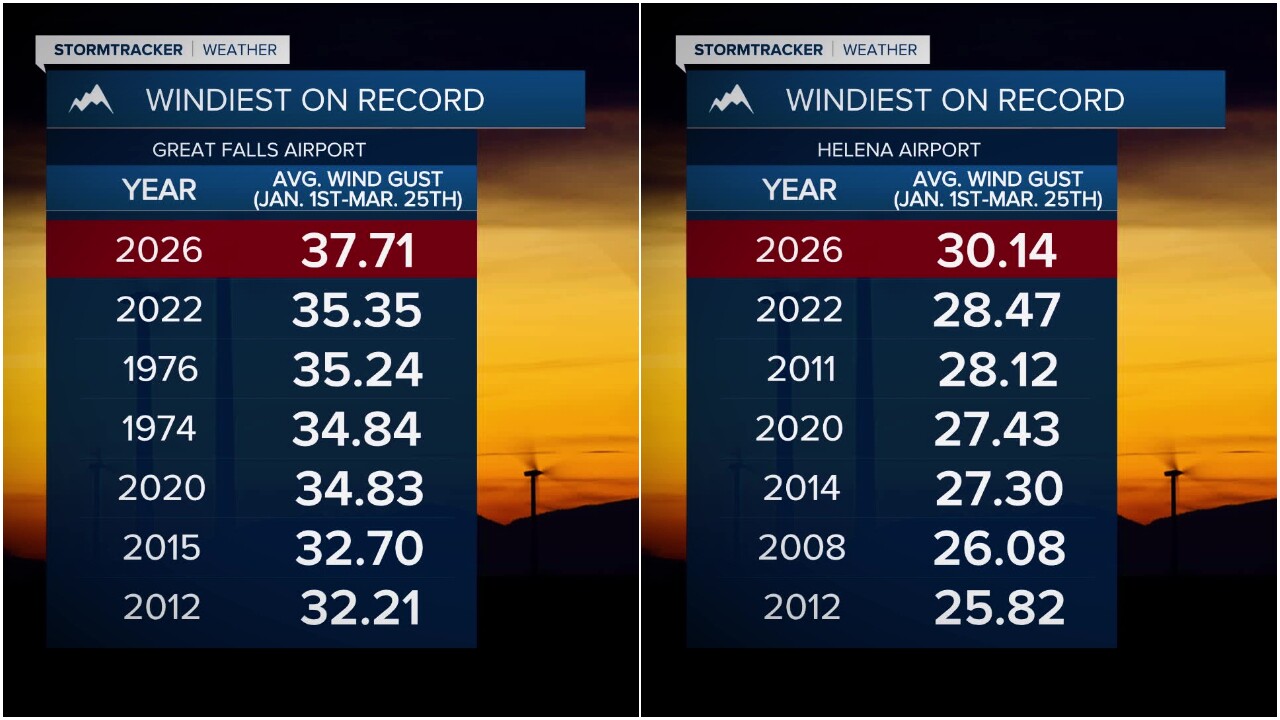

GREAT FALLS — Montana is certainly no stranger to wind, but many of you have been asking -- is this the windiest it's ever been? It likely will come as no surprise that it’s the windiest start to a year on record in Helena and in Great Falls, based on wind gust speed data from the airport.
The wind has been both destructive and relentless. It has torn through everything from the roof of Lincoln Elementary School to the Holiday Village Mall, and even tractor-trailers have not been able to stand up to it.
"Looking at our wind season generally, you start in October and go through about May. This season, 2025-2026, has actually been our windiest on record for average maximum wind gusts," Cody Moldan said.
Erik Johnson reports - watch the video here:
Moldan is the lead meteorologist at the National Weather Service Great Falls office.
Since January 1, 2026, the average wind gust speed has been more than 37 miles per hour in Great Falls.
Even in places more sheltered by the mountains like Helena, the average wind gust speed is over 30 mph, which is also the windiest start to a year on record.
"The one thing that’s been different about this year is we’ve had three major wind events," Moldan said.
Wind events of this magnitude usually only happen once every five or 10 years for the plains of central and north-central Montana. The first was in December, and then there were two more in March.
Video from March 8:
There have been 13 official high wind events, defined by wind gusts of 58 mph or greater, this year in Great Falls alone. That is the highest they have ever recorded.
Last Thursday, March 19th, the Salmond Ranch — located around 25 miles west of Chouteau near the Rocky Mountain Front — recorded a 106 mph wind gust, the strongest wind gust on record in the state of Montana during the month of March.
While Chinook wind events are common in the area, this year’s conditions have been different thanks to a stagnant high-pressure ridge parked over the West.
Incoming Pacific storms create a large pressure difference, driving these winds. An active jet stream right over Montana brings down even stronger gusts from higher altitudes.
The lack of snowpack also plays a role, allowing more surface heating, which further amplifies the wind. As the state transitions from winter to spring, the jet stream becomes especially active.
"There’s light on the horizon. We’re slowly starting to warm up. With warmth, spring still brings wind, so be prepared for more of it," Moldan said.

