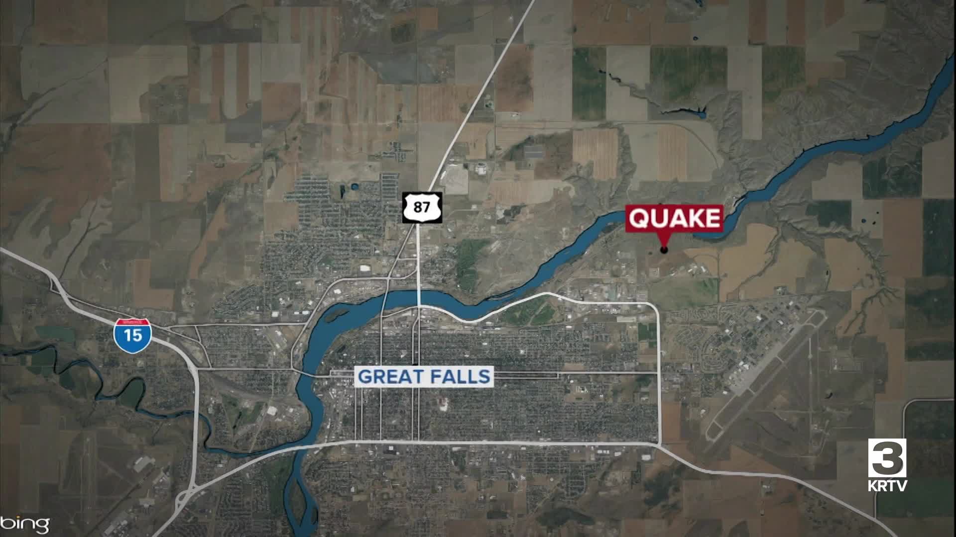


Many people reported feeling what they believe was a small earthquake on Saturday, January 31, 2026 - and the U.S. Geological Survey confirmed that it was a magnitude 3.2 quake.
It happened at 6:22 p.m., and was centered about 1.8 miles northwest of Malmstrom Air Force Base at a depth of six miles.
Among the messages and comments we received:
- Felt it - Fox Farm area behind Heritage Inn
- Sounded like thunder
- We definitely felt it, shook the house.
- We felt it near Countryside Village
- The house shook for about 3 seconds.
- Heard the rumble then felt the shaking
- Felt it by great falls high school
- Central Ave West, we felt it here
- Felt it in Riverview
- My house shook in Valleyview
- Felt in Black Eagle
At this point, there are no reports of any injuries or damage. We will update you if we get more information.
This comes just two days after a magnitude 4.2 quake rattled the area, centered about 4.9 miles northeast of Great Falls.
Seismologists said that small aftershocks are possible in the days after the initial quake, which is likely what happened on Saturday.
On Thursday, KRTV was interviewing Cascade County Sheriff Jesse Slaughter (for an unrelated story) when the earthquake hit - watch the video:
The Treasure State is in one of the most seismically active regions in the United States. The intermountain seismic belt, which runs through the western third of the state, is where most of the earthquake activity occurs in Montana. The vast majority of the many quakes across the region are very small, rarely felt by people, and cause no damage. There is a team of experts at the Yellowstone Volcano Observatory who keep track of them all; click here to visit the website.
There is also an Earthquake Studies Office on the campus of Montana Tech in Butte. It operates the Montana Regional Seismic Network, a network of 42 permanent seismic stations located throughout western Montana. The website notes: "Although it has been over four decades since the last destructive earthquake in Montana, small earthquakes are common in the region, occurring at an average rate of 7-10 earthquakes per day."
The website features several interactive maps, including one that shows the 2,395 earthquakes recorded in Montana during 2018 and additional earthquakes in the surrounding region. All but 23 of those quakes registered as less than 3.0, which demonstrates how small and imperceptible the vast majority are.
There have been some notable earthquakes in Montana’s history, including the 7.3 magnitude Hebgen Lake earthquake on August 17, 1959. The earthquake triggered more than 160 new geysers throughout Yellowstone National Park. There were also around 28 fatalities from a rockslide in Madison Canyon.
And on July 6, 2017, one of the strongest earthquakes to hit Montana in decades shook the community of Lincoln northwest of Helena. It was centered 5.5 miles southeast of Lincoln at a depth of about 2.6 miles. People reported feeling the 5.8 magnitude quake across Montana and the northwest, with some reports coming from as far away as Vancouver and Lethbridge, Canada. It caused some minor damage, but no serious injuries.
In January 2026, a 4.2 quake shook several miles northeast of Great Falls; no injuries and no serious damage were reported - click here for details.
The quake happened at 12:41 p.m., and was centered about 4.9 miles northeast of Great Falls at a depth of about 13.6 miles.
MTN News was interviewing Cascade County Sheriff Jesse Slaughter (for an unrelated story) when the earthquake hit - watch the video:
The plains of central and eastern Montana are much less prone to quakes, but there have been a handful of significant ones reported.
According to the USGS, a 5.3 magnitude earthquake struck northeastern Montana on May 15th, 1909.
Several smaller quakes have been recorded in Roosevelt County, including an estimated 4.5 magnitude quake in the town of Froid that resulted in some damage to a grain bin back in 1943.
Although it has been some time since the state has seen a destructive earthquake, small quakes occur several times every day. Click here to learn more about earthquake preparedness.
