


Happy Friday! There have been scattered showers and thunderstorms around throughout the afternoon and early evening. As we go through the rest of this evening and tonight, there will continue to be scattered showers and thunderstorms around, especially before midnight. Gusty winds, small to medium-sized hail, frequent lightning, and heavy rainfall that could lead to minor flooding will be possible with all the thunderstorms. It is also going to be mild again tonight as lows are going to be in the 50s and low 60s.
Here is the detailed forecast:
A cut-off low will bring cooler and wetter weather to our area this weekend and this cooler and wetter weather will stick around through early next week.
Showers and thunderstorms are likely tomorrow, especially during the afternoon and evening. Similar to today, all thunderstorms that develop tomorrow will be capable of producing gusty winds, small to medium-sized hail, frequent lightning, and heavy rainfall, so make sure you keep an eye to the sky if you are going to be outdoors at all.
There are then going to be areas of rain and a few thunderstorms around tomorrow night. Sunday will be a soggy day as there will be areas of rain around throughout the day, especially in central Montana and western portions of north-central Montana. A few thunderstorms are also possible on Sunday. Some of the rain that falls this weekend will be heavy at times.
A lot of the state will receive beneficial moisture this weekend. From this evening through Sunday evening, .5” to 2” of rain is expected throughout much of the state, with a few areas possibly receiving up to 3” of rain.

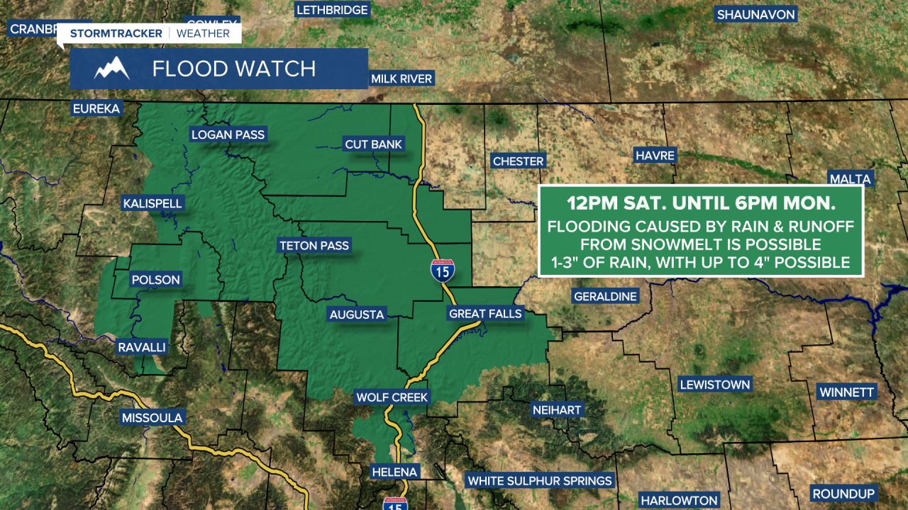
A FLOOD WATCH is in effect for western portions of north-central Montana and portions of northwestern Montana from 12pm Saturday until 6pm Monday. Flooding will be possible in these areas due to excessive rainfall and runoff from snowmelt. Elsewhere, minor flooding will be possible, primarily from heavy rainfall associated with thunderstorms.
The temperatures will cool down a lot this weekend. Highs are going to be in the mid to upper 50s, 60s, and 70s tomorrow, with the coolest temperatures in central Montana and in locations west of I-15 in north-central Montana and the warmest temperatures along the eastern half of the Hi-Line. It is then going to be cool for everyone on Sunday as highs are going to be in the 50s and upper 40s in most locations.
There will be a little bit of a breeze around on Saturday, especially during the afternoon and evening. Widespread breezy/gusty conditions are then expected tomorrow night and Sunday, especially in locations east of I-15, as sustained wind speeds are going to be between 10 and 25 mph, and gusts up to 40 mph are possible.
There will be more scattered showers and isolated thunderstorms around on Monday and Tuesday as this weekend’s storm system continues to impact the state. Neither day looks to be a washout though. It is also going to be mostly cloudy on these two days. On Monday, there will be a breeze around as sustained wind speeds are going to be between 10 and 20 mph. There is then just going to be a little breeze around on Tuesday. The temperatures will also begin to warm back up over these two days as highs are going to be in the 50s and low 60s on Monday and the 60s on Tuesday.
Nice weather is then expected on Wednesday as high pressure will briefly be in control of our weather. On Wednesday, it is going to be partly cloudy, mostly dry, and mild as highs are going to be in the mid to upper 60s and low 70s.
Another round of scattered showers and thunderstorms is expected on Thursday as a disturbance passes through the state. It is then going to be mostly sunny and dry on Friday. It is also going to be mild on these two days as highs are going to be in the upper 60s, 70s, and low 80s.


