


It has been a foggy Christmas Eve in portions of north-central Montana, and some of this fog has been dense with visibility at or below a quarter mile. There has also been some light snow and light freezing drizzle with this fog, so roads are slippery in some areas. There will continue to be areas of freezing fog around through at least the first half of tonight in north-central Montana, and a DENSE FOG ADVISORY is in effect for most of north-central Montana until 11pm tonight. If you are traveling anywhere tonight, be prepared for low visibility and slick roads.

There are going to be scattered rain, freezing rain, and snow showers around tonight as a disturbance passes through our area. Most of this precipitation will be out of our area by sunrise tomorrow, but there will continue to be a few isolated rain, freezing rain, and snow showers around during the day tomorrow. It is also going to be partly cloudy tomorrow.
Here is the detailed forecast:
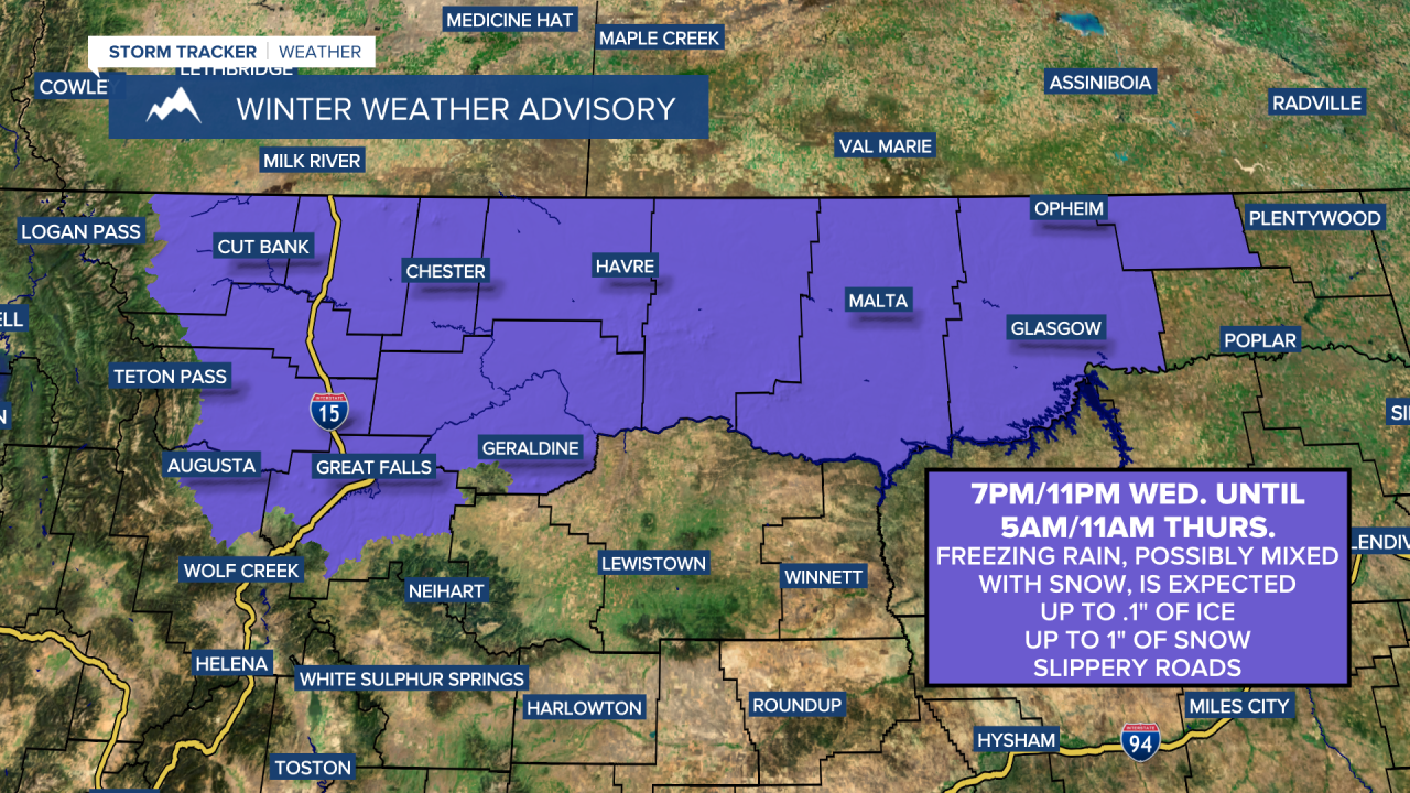
Little (a coating) to no snow accumulation is expected with this disturbance, but up to .15” of ice is possible through tomorrow morning. This ice will make roads extremely slippery in some areas tonight and tomorrow morning, so please use extreme caution when driving and give yourself some extra time to get to where you need to go. Thankfully, road conditions should quickly improve tomorrow for a lot of us as the temperatures will warm well above freezing and there will be some sunshine as well. The ice may linger longer along the Hi-Line east of I-15 though as it won’t be as warm. Due to the forecasted freezing rain, a WINTER WEATHER ADVISORY is in effect for a lot of north-central and northeastern Montana from 7pm/11pm Wednesday through 5am/11am Thursday.

It will be cold tonight in north-central Montana as lows are going to be in the single digits, teens, and low 20s. It will be cool tonight in central Montana as lows are going to be in the mid to upper 20s and low to mid 30s. Tomorrow will be a mild day for most of us as highs are going to be in the 40s and low 50s. However, it will remain chilly tomorrow along the Hi-Line east of I-15 as highs are going to be in the mid to upper 20s and low to mid 30s.
Friday will be partly to mostly cloudy with scattered rain and snow showers around Helena, especially in the mountains, and some scattered rain, freezing rain, and snow showers in north-central Montana, generally in the mountains and in locations east of I-15. It is also going to be breezy in some areas of Friday with 10-25 mph sustained winds, and it will be mild on Friday as highs are going to be in the 40s and mid to upper 30s.
There are then going to be scattered snow showers around Friday night and Saturday, generally during the morning, as a cold front passes through the state. Light snow accumulations of a coating to a couple inches are possible. It is also going to be a lot colder on Saturday as highs are only going to be in the single digits, teens, and 20s, with the temperatures getting colder as the day goes on. It is also going to be blustery Friday night into Saturday as sustained wind speeds are going to be between 10 and 25 mph, and gusts over 40 mph are possible.
Sunday through Wednesday will feature partly cloudy skies and mainly dry conditions as an upper-level ridge is going to be in control of our weather. It will still be cold on Sunday, but it will be warmer than it will be on Saturday as highs are going to be in the teens, 20s, and low to mid 30s (single digits in northeastern Montana). Much warmer temperatures are then expected next week as highs are going to be in the 30s and low to mid 40s on Monday, and the mid to upper 30s, 40s and low 50s on Tuesday and Wednesday. Gusty winds (10-25 mph) will accompany these warmer temperatures, with Monday being the windiest day.


